

Melbourne Airport Facade Condition Assessments
Melbourne Airport, serving as Victoria’s primary international and domestic aviation hub, has been a critical infrastructure asset since its opening in 1970. Over the years, the airport has undergone several expansions and upgrades, resulting in a complex precinct that encompasses four interconnected terminals, two multi-story car parks, and a range of support service buildings. These structures vary widely in age, construction and condition, presenting a unique challenge in asset management. As part of a strategic investment review by the airport’s owner and operator, Australia Pacific Airports Melbourne (APAM), a detailed condition assessment of the airport’s facade elements was identified as vital to inform planning, maintenance, and future investment decisions.
The Challenge
Scale and Complexity of the Project
The sheer scale of the Melbourne Airport precinct posed a significant challenge. The project required assessing over 10 linear kilometres of facades, equivalent to a surface area of approximately 11 hectares. The buildings within this precinct varied in shape and height, adding further complexity to the task. Traditional inspection methods, such as using elevated work platforms (EWPs), ropes, or scaffolding for visual inspection, were deemed impractical due to the irregular building shapes and difficult access points. These conventional methods could have taken several years to complete, posing a risk to airport operations and safety.
Operational Constraints and Safety Requirements
Operating within an active airport environment presented additional challenges. Any data capture or inspection activities needed to be conducted without disrupting the airport’s operations or compromising safety. Strict regulations governed by the Civil Aviation Safety Authority (CASA) and Airservices Australia also had to be adhered to, particularly concerning the use of UAVs (drones) in close proximity to active runways and aircraft. This required meticulous planning and coordination with multiple stakeholders, including APAM, CASA, and various internal airport teams, to ensure that all safety and operational requirements were met.
Data Quality and Integration Needs
Beyond operational and safety considerations, the project also demanded high-quality data that could support a detailed condition assessment of the facades. The data needed to enable detailed defect assessments at sub-millimetre resolution to guide maintenance and investment planning effectively. In addition, APAM required data that was not only accurate and comprehensive but also suitable for integration into their existing Building Information Model (BIM) framework. This requirement necessitated a sophisticated approach to data capture, processing, and integration.
Our Solution
To address these multifaceted challenges, Veris, in collaboration with engineering firm AECOM, developed a comprehensive solution that leveraged advanced digital technologies and innovative methodologies. Our solution was designed to deliver high-resolution data efficiently while ensuring compliance with all operational and safety constraints.
Innovative Data Capture Technologies
We devised a multi-faceted data capture strategy that combined UAV photogrammetry, terrestrial laser scanning, and handheld DSLR photography. This approach allowed our team to overcome the limitations of traditional inspection methods and deliver the required data quality and accuracy within a significantly reduced timeframe.
- UAV Photogrammetry: The primary data capture method involved the use of Unmanned Aerial Vehicles (UAVs) equipped with a 45MP HDR camera. These UAVs were capable of capturing extremely high-resolution imagery, providing detailed visual data of the facades. Given the strict regulations on UAV operations within an airport environment, Veris developed a bespoke tethering solution that ensured the UAVs remained within a safe operating range. The tethered UAVs were equipped with an auto-reeling electric winch system, powered by a portable generator, allowing the drones to operate safely and continuously without exceeding regulatory limits. Over 55,000 photos were captured by the UAV.
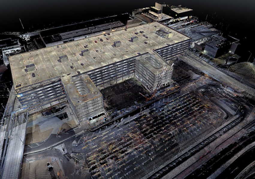
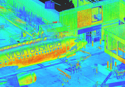
- Terrestrial Laser Scanning: Complementing the aerial data, terrestrial laser scanning was employed to capture precise geometric data of the buildings from ground level. This method provided a detailed 3D representation of the building facades, capturing the structural nuances that UAV imagery alone could not provide. Over 3,500 full colour scans were set up.
- Handheld DSLR Photography: In areas where UAV access was restricted—either due to safety concerns or CASA regulations—handheld DSLR cameras were used to capture high-resolution imagery. This approach ensured that all parts of the facades were documented, even those in challenging or restricted locations. Approximately 6,000 images were captured using this method.
Data Processing and Integration
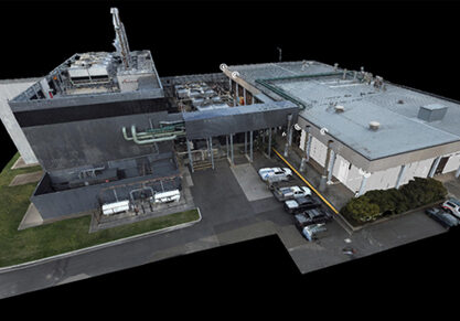
The oblique and horizontal imagery captured through these various methods were then processed to create a high-resolution photo mesh. Generating a photo mesh that is spatially and visually accurate from data captured at acute angles of such facades posed a substantial challenge. Once developed, the immersive photo mesh was crucial for enabling detailed assessments of the facades, allowing for the identification of defects and structural issues with a high degree of precision to sub-millimetre levels.
Cloud-Based Spatial Data Platform
To enhance accessibility and usability, all data, including the photo mesh, high-resolution images and field inspections run in parallel to the survey were uploaded to Veris’ cloud-based spatial data platform, 3SiDe, effectively delivering a Digital Twin of the facades. This provided a centralized location where stakeholders could perform virtual inspections of the entire facade precinct, enabling efficient decision-making and planning. The user-friendly interface of 3SiDe allowed stakeholders to navigate the extensive data set easily, supporting their maintenance and investment strategies with comprehensive, accurate information.
3D Modelling and BIM
Using the point cloud scan data, which included precise building geometry captured by the terrestrial laser scanner, our team developed a 3D Revit model of the facades. This was coupled with the imagery and integrated into the existing BIM framework, facilitating seamless data use across APAM’s asset management systems, which was a key requirement for the project.
Outcomes
The innovative approach adopted by Veris delivered significant benefits to APAM, demonstrating the value of digital technology in complex asset management scenarios.
Efficiency and Cost Savings
By leveraging advanced digital technologies, the project was completed in a compact time frame, with the site-based and data processing components finalized within four months. This timeframe represented a substantial reduction compared to the years it would have taken using traditional inspection methods. The digital approach also eliminated the need for extensive access equipment and manual inspection processes, resulting in significant cost savings.
Improved Safety and Minimal Disruption
The use of UAVs and remote data capture technologies minimized the need for personnel to work at height or in potentially hazardous conditions, enhancing overall safety. The bespoke tethering solution for UAV operations ensured compliance with all CASA regulations and APAM requirements, enabling data capture without disrupting airport operations. This approach not only maintained safety but also preserved the airport’s operational integrity throughout the project.
High-Quality Data and Enhanced Asset Management
The high-resolution data captured through this project provided APAM with a detailed understanding of the facade conditions, enabling them to identify and address defects proactively and virtually. The integration of this data into the BIM framework allowed for increased accuracy in capital works planning and prioritization, supporting a more effective asset management strategy. Further, repeat inspection can be performed in the future and easily updated into the existing framework. The use of the 3SiDe platform to develop a Digital Twin facilitated virtual inspections, reducing risks, enhancing accessibility for stakeholders and enabling more informed decision-making.
Long-Term Strategic Value
Beyond the immediate benefits, the project has provided APAM with a robust foundation for long-term strategic asset management. The detailed data and insights gained through this project will support ongoing maintenance and investment planning, ensuring the resilience and longevity of Melbourne Airport’s infrastructure. The innovative methodologies and technologies deployed have set a new benchmark for digital surveying and asset management within the aviation sector, demonstrating the potential for similar approaches to be applied in other complex, operationally sensitive environments.
The Melbourne Airport facade assessment project showcased the power of innovation and digital technology in addressing complex asset management challenges. Veris, in collaboration with AECOM, delivered a comprehensive, efficient, and safe solution that exceeded the project’s objectives, providing APAM with the data and insights needed to manage their assets proactively. The success of this project underscores the value of a forward-thinking approach to infrastructure management, setting a new standard for the industry.