

Hobart Rivulet Digital Twin
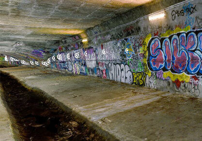
The Hobart Rivulet is a major stormwater asset that lies directly under the Hobart CBD. It is a confined space that is difficult to access and is prone to flooding, impacting asset management. This is further affected by the risks associated with internal defects, where a previous catastrophic wall collapse resulted in damage to adjacent infrastructure and buildings.
The Challenge
The Hobart Rivulet requires regular inspections and maintenance to identify defects and mitigation. However, access to the asset is notoriously difficult and poses significant safety risks. The Hobart City Council (HCC) needed a solution to manage the asset using a safe, efficient and comprehensive approach.
Our Solution
To meet the needs of our client, we delivered a bespoke, end-to-end Digital Twin solution. We combined data capture in the field, 3D visualisation and GIS analysis, with the ultimate delivery of an integrated Digital Twin platform that enables virtual asset and defect management.
Data capture in challenging underground conditions
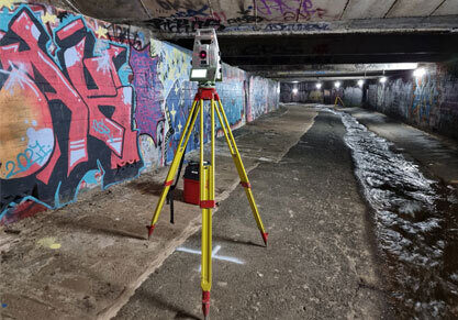
To support the development of the Digital Twin, we performed terrestrial laser scanning and photogrammetry of the Rivulet, encompassing over 170 high-resolution scans and the capture of over 5,000 images in challenging lighting conditions. To ensure spatial accuracy, we also performed a detailed survey through the rivulet with over 1,490 observations to 68 wall stations.
Visualising the asset in an immersive, web-based 3D reality mesh
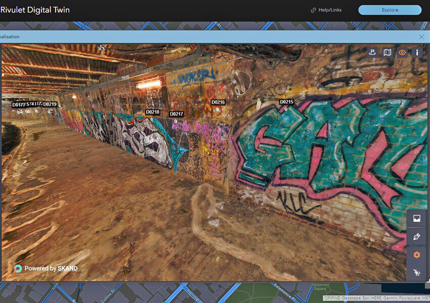
We used the data to build a high-resolution 3D reality mesh of the Rivulet. The immersive 3D mesh, which is hosted on our web platform 3SiDe, is the perfect tool for asset managers, contractors and other stakeholders to visualise, monitor and plan remediation works remotely without the need for a site visit.
QR codes help retrieve and update a rich array of data in the field
We used QR codes placed within the Rivulet to link the physical and virtual assets. The QR codes not only easily identify the location of defects, but can also be scanned using a mobile device to retrieve a rich array of digital information pertaining to the defect type, the condition of the asset and likely mitigations. Using the power of ArcGIS Online, the asset data is live and can be continually updated in the field to streamline workflows and provide real-time inputs to the Digital Twin.
A 2D overview with cadastral boundaries
It was important for HCC to understand and visualise the context of the Rivulet within with wider area, particularly in relation to cadastral boundaries. If rectification works are required, this enabled the identification of adjacent properties for notification. To meet this requirement, we deployed our expertise in GIS to provide a 2D overview inclusive of maps, cadastral boundaries and the location of defects.
A complete Digital Twin – combining 2D and 3D with live data
To create a truly user-centric experience, Veris combined both 2D and 3D in the Digital Twin platform and deployed it to users to visualise the high-quality mesh, which coupled with the asset inspections gives users a live data link to the asset condition.
Integrating the 2D and 3D solutions provides an easy way to leverage the simplicity and powerful analytics of 2D GIS web maps, and the detailed, immersive data of the 3D experience.
The Veris created Digital Twin allows users to explore the features, update the defects and encroachments data, generate reports for contractors and inform planning and development on the Rivulet, all in the one platform.
Outcomes
The Digital Twin solution developed by our team is enabling:
- Asset Managers to identify and monitor defects over time.
- Engineers and contractors to use mobile devices to retrieve and update defect information with real-time streaming into the Digital Twin.
- A safe and efficient alternative to manage the Rivulet without having to enter the site.
- Powerful modelling and analytics including the ability to model water flows and future inundation scenarios.